New Publication Co-Authored by PROTECT Researchers Establishes Approach to Identify PFAS Contamination
A new paper published in Environmental Science & Technology Letters talks about a conceptual approach to map per- and polyfluoroalkyl substances (PFAS) contamination sites throughout the US. The paper was co-authored by PROTECT Research Translation Coordinator Phil Brown and PROTECT collaborator Julia Varshavsky.
PFAS have been measured at unhealthy levels in drinking water systems, people’s bodies, and rainwater. Research shows that PFAS exposure affects almost all organ systems in the human body, and a CDC review found that some of the health effects associated with exposure can include liver damage, decreased fertility, and increased risk of asthma. Though PFAS contamination presents a major public health issue, the cost and resource intensity of PFAS testing has resulted in uneven and incomplete data regarding the scale, scope, and severity of contamination sites in the US. This is information that is necessary for preventing further exposure.
In this paper, researchers argue that they can presume PFAS contamination around three types of facilities: fluorinated aqueous film-forming foam (AFFF) discharge sites (major airports, military sites, and other firefighting training sites), certain industrial facilities that produce and/or use PFAS, and sites related to PFAS-containing waste. Once researchers set these assumptions, they integrated available geocoded, nationwide data sets into one single map to show the locations of presumptive contamination sites in the US.
The established map of presumptive contamination shows 57,412 sites of PFAS contamination. 49,145 of the sites are industrial facilities, 4,225 are wastewater treatment plants, 3,493 are current or former military sites, and 519 are major airports. This already high number of contamination sites is likely an underestimation. However, the goal of this approach was not to identify every possible site location, but to develop a conservative and actionable model using the best data available. The conceptual approach used here could allow governments, industries, and communities to identify and address potential PFAS exposure sources quite rapidly, which could inform regulatory action in stopping ongoing and future contamination.
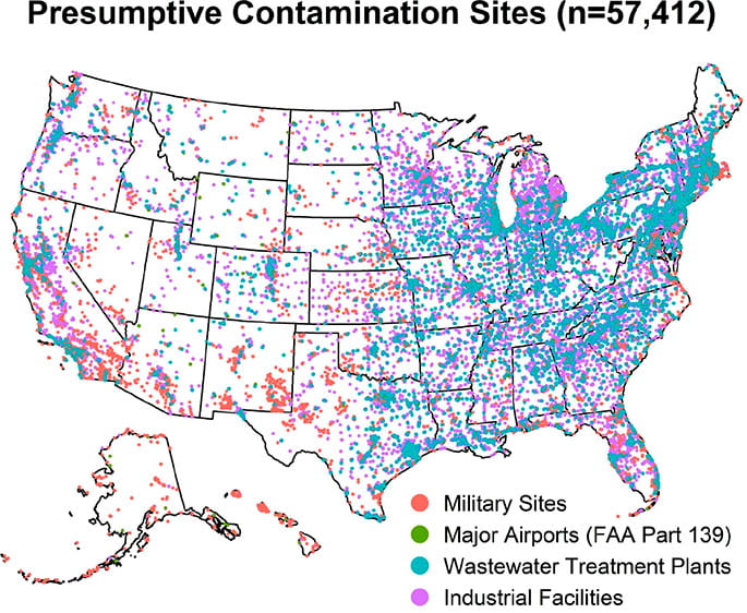
The presumptive PFAS map established by researchers.
One challenge to address going forward is the inclusion of U.S. territories like Puerto Rico on the presumptive contamination map, which were left out because of a lack of data. A way to address this is for federal and state agencies to use resources to develop and disseminate information regarding the sources of presumptive PFAS contamination. This would ensure that all individuals have a better understanding of the contamination in their community.
PFAS present a major issue for human health, communities, and the environment. Swift regulation and exposure reduction are necessary to curb the harms of contamination. As widespread PFAS testing continues to be a challenge, the presumptive contamination model presented in this paper could allow for better identification and investigation of contamination sites right now.